Traumpfad Streuobstwiesenweg
- start: 56218 Mülheim-Kärlich, Sportplatz Dalfter (Holzstraße/Blütenstraße)
- destination: 56218 Mülheim-Kärlich, Sportplatz Dalfter (Holzstraße/Blütenstraße)
- easy
- 9,04 km
- 3 hours
- 246 m
- 208 m
- 93 m
- 60 / 100
- 20 / 100
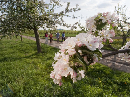
The awakening of spring and blossoming fruit trees! Fabulous panoramic views and a charming route which will also fire the enthusiasm at any other time of the year. Exciting stop-off points to provide experiences for all the senses
Highlights along the trail
- Stop-off points including an insect hotel, a dendrophone, “guess the tree” challenges and an informative and educational fruit path.
- Fabulous vistas of the Volcanic Eifel, a Rhine Valley panorama extending across the whole of the Neuwied Basin and offering far-reaching views of the Westerwald.
- Fruit trees, meadow orchards and a route lined with long-forgotten varieties.
Impressions
General information
Directions
Our trail begins at the car park of the Dalfter sports ground above the town of Kärlich, and we are immediately rewarded with a first spectacular view of the Rhine Valley. The route then plunges into magnificent fruit tree meadows presenting a single sea of white and pink during spring.
We then ascend to the Kettig barbecue hut to enjoy a fine panoramic outlook. We pass through a picturesque mix of woodland, fruit meadows and grassland and arrive at our first stop-off point – an educational fruit trail. Continuing downhill through the woods into the Kettig Valley, we come to the Arenz meadow orchard and then to Kettig brook. We proceed along a route lined by gnarled elderberry trees and other fruit tree meadows and walk upwards onto a plateau which offers a superb panorama of the Volcanic Eifel. Marvellous views are also available during the next section of the trail across open fields. Beside a row of trees, two further stop-off points await us – an insect hotel and a dendrophone. Passing a small orchard, we come to a small wood on the edge of the Karl-Heinrich clay pit where we encounter some undergrowth. A grassy path takes us past a chapel and back into the meadow orchard landscape. Shortly afterwards, after some changes in direction, the route leads up onto a hill with splendid and sweeping views of the Rhine Valley. At the edge of the forest, a narrow path runs down to the Dalfter barbecue hut. We now ascend through a beechwood to reach the viewing platform of the clay pit. A brief and slightly rough descending pathway brings us back to our starting point.
Safety Guidelines
Safety guidance – stay safe whilst hiking on the Traumpfade/Traumpfädchen
Hikers like narrow pathways, unspoilt natural trails (leading over the forest floor, across the grass or alongside streams) and rocky climbs which lead to spectacular views. It goes without saying that particular care should be exercised when taking such routes.
Things to bear in mind when preparing for your hike
- Wear proper clothing that is appropriate to the weather conditions and that will protect you against the cold and the wet or the heat and the sun.
- Schedule suitable breaks during your hike and make sure that you conserve energy.
- Take sufficient liquids with you. Establishments selling refreshments are not available everywhere.
- When hiking on the Traumpfade, please wear appropriate hiking boots which provide a sufficient foothold on slippery, steep, rocky and uneven paths.
- If you do not feel that you are able to negotiate certain parts of the route, then you should avoid such sections or else turn back. Natural pathways may become muddy and treacherous, especially in unfavourable weather.
- In autumn in particular, please remember that leaves lying on the ground may be concealing bumps, routes, stones or holes in the path.
- You will need to expect route impairments of this kind if you are intending to undertake a hike.
- Before setting out, visit https://www.traumpfade.info/traumpfade/wege-status/ in order to find out whether the route you intend to hike is closed or whether diversions are in place. Construction works, timber felling or other disruptions may also be planned.
- Recommended hiking season: April to October.
Difficulty rating:
Easy tours
...have only slight differences in altitude and can usually be completed in half a day in terms of distance. They are not particularly demanding in terms of fitness and surefootedness. There are no sections of the trail that require a head for heights. Short, steeper sections are possible. Depending on the trail format, some sections may be difficult to walk in wet weather.
Medium tours
...are easy to manage with a normal level of fitness. Path sections may require good sure-footedness, so sturdy footwear is important, hiking poles may be useful. Some longer and steeper ascents and descents are possible. Difficult (partly secured) passages are the absolute exception and can usually be avoided by taking a detour. Natural sections can be difficult in wet weather.
Difficult tours
...require very good stamina and endurance due to the length and/or the meters of altitude to be covered. You also need to be very sure-footed to tackle steep ascents and descents on sometimes challenging paths. Rope-secured sections and/or easy climbing passages, which require a minimum of freedom from shingles, are possible. Sturdy footwear and hiking poles are important. Paths and exposed passages are often difficult or even impossible to walk in wet or wintry weather.
Equipment
Surefootedness and a head for heights are required in some sections.
You should not embark upon the tours in icy conditions.
Robust footwear is recommended!
Details of route closures can be found at: http://www.traumpfade.info/wegemanagement/
Tip
+++Wichtige Hinweise und Tipps - insbesondere im Frühling+++
Blüteprognose:
Die Vollblüte ist da! Zeitgleich zu den Kirschbäumen blühen nun auch die Apfelbäume und die Rapsfelder, die gelbe Farbakzente in die Landschaft setzten.
Insgesamt hat sich die Blüte witterungsbedingt in diesem Jahr sehr beeilt. Wir gehen derzeit davon aus, dass ab Mitte April der Blütenzauber abnimmt. (Stand: 10.04.2024)
Liebe Wandergäste,
vor allem in der Blütezeit entfaltet der Traumpfad Streuobstwieseweg seinen ganz besonderen Charme. So machen sich hauptsächlich im Frühjahr sehr viele Wanderer aus Nah und Fern auf zum Streuobstwiesenweg. Im Frühjahr steht ein zusätzlicher Parkraum auf dem angrenzenden Sportplatz zur Verfügung und eine Ampelanlage regelt den Verkehr im Zufahrtsbereich. Beachten Sie bitte auch die aktuelle (Umleitungs-)Beschilderung vor Ort.
WIR BITTEN ALLE BESUCHER
⇒ Verkehrsregelungen vor Ort beachten
⇒ Wenn erforderlich, Alternativparkplätze aufzusuchen
⇒ Alternativwanderwege (siehe Tipps) aufzusuchen
⇒ Die Natur zu achten: Auf der Wegeführung bleiben, Müll/Hundekot mitnehmen, Bäume unbeschädigt lassen.
Anreise:
PARKPLÄTZE
⇒ Einstiegsportal am Sportplatz „Dalfter“
Adresse: Über den Boschwingerten, 56218 Mülheim-Kärlich
ALTERNATIVE PARKPLÄTZE
⇒ Förder- und Wohnstätte gGmbH
Wichtig: Ausgewiesene Parkplätze NUR an den Wochenenden und Feiertagen
Adresse: Anne-Frank-Straße 1, 56220 Kettig
Zuwegung zum Streuobstwiesenweg (Elmar-Hillesheim-Wiese) 200 m
⇒ Raiffeisenplatz / Burgstraße, Stadtteil Kärlich
(Achtung Baustelle bis 5.4.2024)
Burgstraße, 56218 Mülheim-Kärlich
Zuwegung zum Einstiegsportal 1,2 km
⇒ Parkplatz Lukasmühle am Regenrückhaltebecken
Adresse: Bassenheimer Straße, Mülheim-Kärlich (K 88)
Zuwegung zum Streuobstwiesenweg 1,7 km über den MK 6
Gesamtweglänge: 12,4 km (3,4 über MK 6 und 9 km Traumpfad)
ÖPNV-ANREISE
Buslinien › siehe: VRM-Fahrplanauskunft
330 Neuwied – Weißenthurm – Kettig – Mülheim-Kärlich – Bubenheim – Metternich – Koblenz
331* Bubenheim – Mülheim-Kärlich Gewerbepark – Urmitz-Bahnhof – Mülheim-Kärlich – Bassenheim (* 331 an Sonn- und Feiertagen nur ab / bis Urmitz-Bahnhof)
327** Andernach – Weißenthurm – Mülheim-Kärlich – Bubenheim (** 327 nur an Schultagen)
332*** Urmitz-Bahnhof – Weißenthurm – Kettig (*** 332 | 336 nicht an Sonn- und Feiertagen)
336*** Weißenthurm – Kettig – Weißenthurm (*** 332 | 336 nicht an Sonn- und Feiertagen)
⇒ Ortsmitte Kettig
Buslinie: 330, 332*** | Kirche oder 336*** | Mittelweg
Adresse: Ecke Hauptstraße/Breitestraße/Kirche, 56220 Kettig
Zuwegung zum Streuobstwiesenweg (Obstlehrgarten, Grillhütte) 900 m oder 1,2 km
⇒ Raiffeisenplatz, Mülheim-Kärlich
Buslinie: 330 und 331* | Raiffeisenplatz
Adresse: Burgstraße, 56218 Mülheim-Kärlich
Zuwegung zum Einstiegsportal „Dalfter“ 1,2 km
⇒ Stadtmitte, Mülheim-Kärlich
Buslinie: 330 und 331* | Rathaus
Adresse: Ecke Poststraße / Kapellenstraße, 56218 Mülheim-Kärlich
Zuwegung zum Streuobstwiesenweg 1,5 km
⇒ Waldmühle, Mülheim-Kärlich
Buslinie: 331* | Mülheim-Kärlich Waldmühle
Adresse: Waldmühle 1, 56218 Mülheim-Kärlich (Kreisstraße 88)
Zuwegung zum Streuobstwiesenweg 1,8 km
Bahnanreise
Linienbus ab Bahnhof Mülheim-Kärlich (Stadtteil Urmitz-Bahnhof) oder ab Bahnhof in Weißenthurm
+++ Tipps +++
TIPP 1 Verlängerung des Wandervergnügens:
Der Regionale Rundwanderweg MK 6 (Holunderweg) startet in Mülheim-Kärlich am Regenrückhaltebecken/Lukasmühle und trifft nach 1,7 km auf den Streuobstwiesenweg. Unterwegs werden zahlreiche Obstbaumfelder passiert. Gesamtlänge: 12,4 km (3,4 km über MK 6 sowie 9 km Traumpfad)
TIPP 2 Umstieg zu alternativen Wander- & Spazierrundwegen mit Blütengenuss:
Rundwanderweg MK2 „Am Roten Kreuz“
Hier blühen die Obstbäume zuerst, da es sich hier um eine "Frühe Lage" handelt.
Der Weg ist 6,4 km lang und leicht bis mittelschwer.
Ausgangspunkt ist die Grillhütte Hümmeroth | Adresse: Koblenzer Straße, 56218 Mülheim-Kärlich
Rundweg MK3 - Kirschblüten-Panoramaweg
Der Weg ist 4,1 km lang und leicht bis mittelschwer.
Ausgangspunkt: Parkplatz am Nass-Spielplatz | Adresse: Hoorweiherstraße, 56218 Mülheim-Kärlich
Rundwanderweg MK6 - Holunderweg
Der Weg ist 7,8 km lang leicht bis mittelschwer.
Ausgangspunkt: Parkplatz am Regenrückhaltebecken/Lukasmühle
Adresse: Bassenheimer Straße, 56218 Mülheim-Kärlich
Getting there
B 9 exit Weißenthurm/Mülheim-Kärlich/Kettig - follow K 65 in the direction of Mülheim-Kärlich - 1st right into Weißenthurmer Straße - after approx. 700 m turn right into Burgstraße then right again into Hauptstraße - turn left follow signs to "Dalfter Sportplatz".
56218 Mülheim-Kärlich, Dalfter sports field (across the Boschwingerten)
At flowering time: See more parking spaces and paths under parking
Parking
56218 Mülheim-Kärlich, sports field Dalfter (About the Boschwingerten)
PLEASE USE THE FOLLOWING PARKING LOTS AND ACCESS ROADS, ESPECIALLY DURING THE FLOWERING PERIOD
Parking lots/access roads:
56218 Mülheim-Kärlich (Kettiger Straße 33) parking area at the Schützenhaus Kärlich; access to the entrance portal 700 m (access is signposted).
56220 Kettig , (Anne-Frank-Straße 1) Parking lot Förder- und Wohnstätte gGmbH (Important: Use parking lots only on weekends and holidays);
Access road to the meadow orchard path (Elmar-Hillesheim-Wiese) 200 m (access road is signposted)
56218 Mülheim-Kärlich (Raiffeisenplatz / Burgstraße); access road to the entrance portal 1.2 km (access road is signposted)
56218 Mülheim-Kärlich (Bassenheimer Straße, Mülheim-Kärlich (K 88) Lukasmühle parking lot at the rainwater retention basin; access to the meadow orchard trail 1.7 km via hiking trail MK 6
Park & Ride
Parking lot of the Mülheim-Kärlich school and sports center.
Address: Judengässchen 1, 56218 Mülheim-Kärlich
Bus lines: 327*, 331 | Schulzentrum/Tauris - Raiffeisenplatz
Access to the entrance portal "Dalfter" 1.2 km
Public transit
Destination stop: Kettig, church
Line 332 Kettig-Weißenthurm-Urmitz train station - Mülheim-Kärlich industrial park
Line 327 Bubenheim-Mülheim-Kärlich-Andernach
Line 330 RegioBus Neuwied-Weißenthurm-Mülheim-Kärlich-Bubenheim
Access to the meadow orchard path (educational orchard, barbecue hut) 900 m
Destination stop: Mülheim-Kärlich, Raiffeisenplatz
Line 327 Bubenheim-Mülheim-Kärlich-Andernach
Line 330 RegioBus Neuwied-Weißenthurm-Mülheim-Kärlich-Bubenheim
Line 331 RegioBus Bassenheim-Mülheim-Kärlich-Urmitz train station - industrial park Mülheim-Kärlich-Bubenheim
Access to the "Dalfter" boarding gate 1.2 km
Rail journey
Train ride to Urmitz train station - change to bus line 331 (direction Bassenheim) - get off at Mülheim-Kärlich bus stop Raiffeisenplatz
Train ride to Weißenthurm station - change to bus line 330 (direction Koblenz) - get off at Mülheim-Kärlich stop Raiffeisenplatz
Literature
Traumpfade 2 – Schönes Wandern Pocket. Premiumwege an Rhein, Mosel und in der Eifel (7 Traumpfade) Ulrike Poller & Wolfgang Todt ISBN: 978-3-93-43-42-613
Maps
Top. Karte "Oberes Mittelrheintal/Koblenz (1:25.000) ISBN: 978-3-89637-363-2
Additional Information
Verbandsgemeinde Weißenthurm, Tel.: +49 (0)2637/913-0, touristik@vgwthurm.de, www.mittelrhein-touristik.com
Rhein-Mosel-Eifel-Touristik, Tel.: +49 (0)261/108419, info@traumpfade.info, www.traumpfade.info
Traumpfade App
Traumpfade App for iOS: Download the app from iTunes
Traumpfade App for Android: Download the app from Google Play
Weather

This tour is presented by: Traumpfade im Rhein-Mosel-Eifel-Land, Author: Nicole Pfeifer


