Moselsteig Side Trail Klüsserather Sagenweg
- start: Portal at the parking area at the Klüsserather weather station
- destination: Portal at the parking area at the Klüsserather weather station
- medium
- 11,90 km
- 4 hours
- 290 m
- 310 m
- 145 m
- 80 / 100
- 40 / 100
A hike of legends and spooky experiences.
You will come across many legendary stations during the course of this premium hiking trail - with its 11.9 km of varied and typical Moselle wine and cultural landscape. This way, hikers can enjoy, for example, a very beautiful view of the Rudemsberg. Here, the “Rudemsmännchen” is rumoured to still be the source of spooky mischief and frightening encounters, as many years ago it ended a border dispute in its favour through a false oath. At the height between Trittenheim and Klüsserath, the trail passes the “Eselstrapp”, also known as “Hinkelstein” with magnificent views of the Moselle Valley. As legend has it, a maiden riding on a mule saved herself from her pursuers with a jump into the Valley. The hoof print of the mule can still be seen on a large standing stone, a Celtic menhir.
The eponymous village of Klüsserath with its significant cultural-historical townscape and wide range of restaurants can be easily reached via the access routes.
Impressions
General information
Directions
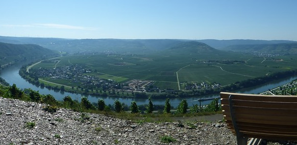
The starting point for the Side Trail Klüsserather Sagenweg is the portal at the parking area at the weather station. No matter how you arrived at the lounger bench and information board telling the legends of the crusaders (either by car or via the 2.5 km long access route through the vineyards), you must enjoy the panorama views before starting your hike. You can see the entire Moselle loop from Klüsserath. A sea of grape vines, a myriad of wine villages line up along the blue band of the Moselle. A grandiose prelude for a varied round trip.
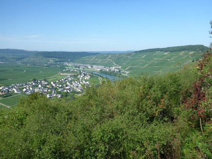
At the beginning the tour takes you at a comfortable pace along the edge of the forest and vineyard, without any inclines or declines. At the paraglider launch site (again a great view) the Side Trail then changes into a steep forest path which winds uphill at a serious incline, to the open plateau. Here, it continues briefly downhill and half circles an orchard. Passing old fruit trees, you continue downhill into the vineyards. First, only on one side, thereafter the path is lined by vines to the right and left. Back on the slope edge, the Klüsserather Sagenweg runs evenly along the slope edge. The view of the Moselle is unfortunately blocked by hedges and shrubbery. All the more impressive and surprising is the view from the soon reached Hinkelstein. The panorama covers the entire Moselle Valley between Pölich and Trittenheim. The resting place and loungers invite you to enjoy distant views. The "Hinkelstein" is an approximately 3500 year old Menhir from the Neolithic period. The legend of the Eselstrapp (see the information board) involves this stone.
You continue downhill through the vineyards. From the meadow you can catch a glimpse of the Moselle. The Side Trail has changed sides over the mountain spur. You already have a view of the vineyards of Neumagen. For this, the Moselle needs about 7 kilometres of river, the hiking trail, not even 500 metres. Steeply downhill the Sagenweg arrives at a jungle-like side valley. The zig-zag path leads through an old vineyard terrain, which you can recognise by the remaining vineyard pens. After a short section uphill, you cross a stream, then the path gets closer to the Moselle Valley, still continuing downhill. Hiking through vineyards you arrive at the view of the Martyr's Chapel, just before the forest. The lounger is ideally placed here, for enjoying the view of the chapel on the other side of the Moselle.
The Side Trail continues 2 km uphill through the shady forest. Not steep, but noticeable. Due to the trees on the steep slope, views are blocked, but the view of the "Türmchen" tower on the other side of the Moselle near Neumagen is really great. You reach this at the end of the ascent via a path. This is a barbecue and mountain hut with rest areas. Perfect for a stopover after all the strain.
You continue on a path. This takes you steeply uphill through the oak forest, accompanied by moss-covered slate rocks.Over a soft forest path you continue at a moderate incline downhill into the quiet Moselle side valley. At the stream, the Side Trail has reached the lowest point of this round trip. The Moselsteig Trail is only 100 m away and hikers can reach Neumagen (restaurants and accommodation) from here via the same access route. You have also covered half of the stretch.
The path continues steeply uphill into the Kerbtal, quickly gaining altitude. Once you reach the cross-way, the slope becomes flatter. However, in the slope it continues uphill. The Kerbtal becomes narrower and in parts, is more of a gorge. At the height the Klüsserather Sagenweg meets a large field. The ascent is almost done. The bench on the top edge of the forest offers a view of the plateau right to the Hunsrück. You can also read up on the legend of the Geldkaul on the information boards. At a large crossing in the forest, the highest point of the Side Trail is reached. You now continue on a flat forest path to the Klüsserather barbecue hut. There are also ideal resting places here for breaks on hot days.
Without great differences in height, we continue through the forest. The trail marks indicate that you are on an ancient pilgrimage path. Parallel to a moat, the path leads downhill to a fountain and other resting places. Then the path has reached the vineyards again. Surrounded by vines, the Side Trail first passes a bench, and then continues steeply downhill to a lounger. Again with fantastic views. You look at the mouth of the Eifel rivers Salm into the Moselle. Here, a short steep access route to the parking area at the Klüssserather church branches off. The information board tells the legend of the Rudemsmännchens.
The vineyard path now leads through the Klüsserather Bruderschaft vineyard. The vineyards fall so steeply towards the Moselle that the entire trail offers a magnificent view of the wine-growing landscape. The houses of Klüsserath seem only a stone's throw away, but deep down in the valley. A steep serpentine path takes the hiker along the slope edge. Follow this comfortably without differences in altitude to the starting point at the Klüsserather weather station.
Even if you already know the view from the way here, the panorama views are simply magnificent!
Tip
Entering this circular route at Neumagen is an also excellent option. From here, a short access route leads over the Moselle Bridge to the Klüsserather Sagenweg. Advantage of this entry point: The access route meets the Side Trail at the lowest point, i.e. no additional height difference on the access route.
In "flying weather" you should plan in some extra time for watching the paragliders. The starting point is very close to the entry portal. Sometimes several dozen paragliders can be seen at the same time.
Getting there
B 53 between Schweich and Bernkastel. The Klüsserather weather station is accessible via paved vineyard trails.
Parking
Parking directly at the starting/end point.
Parking at the Klüsserather church. From here, an about 1 km long path and 2.7 km long access route takes you to the Side Trail.
Public transit
Klüsserath can be reached by line 333.
Literature
Literature (only available in German):
"Seitensprünge" Band 1 - 10 Premium-Rundwanderungen von Trier bis Bernkastel-Kues von ideemedia
Authors: Ulrike Poller, Wolfgang Todt, Publisher: ideemedia, 114 pages, Format: 11,0 x 16,4 cm, ISBN: 978-3-942779-59-3, 12,95 €
Maps
Leisure Map Moselsteig Trail – Map 2: Trier - Zell (Moselle) (Stages 5 - 14), ISBN: 978-3-89637-420-2
Additional Information
Mosellandtouristik GmbH
Kordelweg 1, 54470 Bernkastel-Kues; Phone: +49 (6531) / 97330
Tourist information office Römische Weinstraße
Brückenstr. 46, 54338 Schweich; Phone. +49 (6502) / 933812
Pavings
- Crushed Rock (12%)
- Path (12%)
- Hiking Trail (75%)
- Asphalt Coating (1%)
Weather

This tour is presented by: Verein Römische Weinstraße e.V., Author: Mosellandtouristik GmbH


