Höllenweg - Hike N 7 Nittel
- start: Rehlingen, Am Haarberg
- destination: Rehlingen, Am Haarberg
- medium
- 8,32 km
- 2 hours 15 minutes
- 201 m
- 386 m
- 186 m
- 100 / 100
- 60 / 100
Demanding and varied hike from Nittel-Rehlingen.
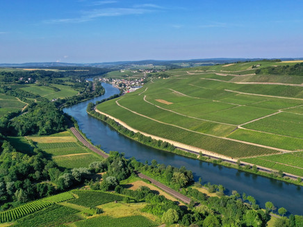
The somewhat more challenging Höllenweg trail, which starts in Rehlingen, showcases the region's scenic diversity and magnificent views and leads past vineyards, forests, meadows and fields to the quiet and beautiful district of Köllig with its lavishly restored old farmhouses. With a view of the hamlet of Soest, the route leads back through the "In der Höll" forest district and past abandoned old vineyard terraces in a side valley to Rehlingen.
Impressions
General information
Directions
The trail with the orange markings starts in the Rehlingen district in the street Am Haarberg. It first leads along the vineyards, past the cemetery and the edge of the forest to Köllig. At the cemetery, you should definitely plan a detour to St Martin's Chapel. Here you can enjoy a fantastic view of the Moselle. In Köllig, continue along Im Hübelgarten and Fischer Wild and turn right into Am Grauen Stein at the end of the village. Continue straight ahead along a farm track before turning right after the fourth crossroads. Now walk below the village of Söst to the barbecue hut. With a view of the hamlet of Soest, the route leads back through the forest district of In der Höll and past abandoned old vineyard terraces in a side valley to Rehlingen.
The hike is signposted throughout with the "N7" marker.
Equipment
Sturdy shoes!
Tip
St Martin's cemetery chapel in Nittel-Rehlingen.
Getting there
You can reach Nittel-Rehlingen from Perl or Konz via the B 419, or from Saarburg via the L 135.
Parking
Free parking is available at the cemetery and at the Moselblick car park in Bergstraße.
Public transit
Information on current public transport timetables can be found at www.bahn.de or www.vrt-info.de/busnetz.
Literature
You can obtain tips and information as well as free brochures and maps of the Saar-Obermosel holiday region from Saar-Obermosel-Touristik with the tourist information offices in Konz (Tel. 06501-6018040) and Saarburg (Tel. 06581-995980).
Or order the brochures you require directly from our online brochure shop.
Tip: Saar-Obermosel guest newspaper, Saar-Obermosel leisure map.
Maps
The local hiking map with the exact route is available free of charge from the accommodation providers in Nittel, the village bakery and the Moselle pharmacy in Nittel.The map is also available from Saar-Obermosel-Touristik at the tourist information centres in Konz and Saarburg.
Additional Information
Saar-Obermosel-Touristik, Tourist-Information Saarburg, Graf-Siegfried-Str. 32, 54439 Saarburg, Tel. 06581-995980.
Saar-Obermosel-Touristik, Tourist-Information Konz, Saarstr. 1, 54329 Konz, Tel. 06501-6018040.
E-mail: info@saar-obermosel.de
Visit our website for exclusive tips and information about the Saar-Obermosel holiday region and follow us on social media:
https://www.saar-obermosel.de/
https://www.facebook.com/saarobermosel
https://www.instagram.com/saarobermosel
https://www.youtube.com/@saarobermosel4183
You can find more information about a stay in Nittel at: https://www.nittel-mosel.de/
Pavings
- Asphalt Coating (6%)
- Crushed Rock (75%)
- Street (10%)
- Hiking Trail (10%)
Weather

This tour is presented by: Saar-Obermosel-Touristik e.V , Author: Saar-Obermosel-Touristik e.V.

